
Low-cost Quality Digital Twins
LiDAR and imagery acquisition, photogrammetric extraction, and AI-powered geospatial intelligence — delivered as a turnkey service for infrastructure, mobility, and urban planning.
How we compare
LiDAR-class density at ~1% of the cost.
~2 cm point spacing on the road surface, RTK-metric — dense enough to measure curbs, lane markings, signs and poles — captured with a 360 camera on any vehicle, at a fraction of survey-LiDAR hardware cost.
| Aerial LiDAR | Survey mobile LiDAR | 4D-360 | |
|---|---|---|---|
| Point spacing on road | ~30–50 cm | ~1–3 cm | ~2 cm |
| Density near trajectory | 8–30 pts/m² | 100s–1000s/m² | 100s–1000s/m² |
| Survey-spec benchmark | USGS QL1–QL2 | far exceeds | exceeds USGS QL0 |
| Metric / georeferenced | yes | yes | yes (GPS / RTK) |
| Absolute position accuracy | ~15–30 cm | ~1–3 cm | ~1 cm (RTK-fixed) |
| Geolocated video frames | no | no | yes — every 360° frame placed to the centimetre, even at highway speed |
| Capture platform | aircraft | dedicated survey vehicle | any vehicle + camera |
| Hardware cost | very high | high | a fraction |
| Feature extraction | days–weeks, manual | days–weeks, manual | hours, fully automated |
| Detectable assets | predefined catalog | predefined catalog | open — describe any asset in plain language, then measured in 3D |
| End-to-end turnaround | ~weeks | ~3 days – weeks | ~1 day |
| Point-cloud generation | ~days | ~½–2 days | ~7 h |
| Data volume (100 mi) | multiple TB | multiple TB | ~GB, streamable |
| Photoreal scene | no | no | yes — real footage, no expensive Gaussian Splatting to generate or store |
| Primary deliverable | point cloud only | point cloud only | navigable 360° video + measurable cloud + tap-to-measure |
| Access & delivery | files to download & host | files to download & host | SaaS — streamed in-browser, no egress or storage costs |
Photogrammetric (passive) density tapers with range and is lower under heavy canopy, as with any mobile system; LiDAR retains advantages in low light and direct range accuracy. Figures are point spacing on the road surface near the trajectory.
How it works
One drive-by, four stages — each output feeds the next.
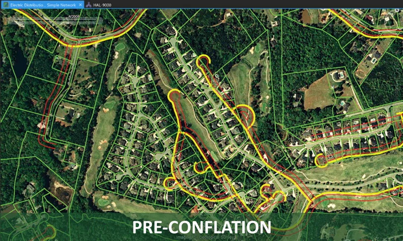
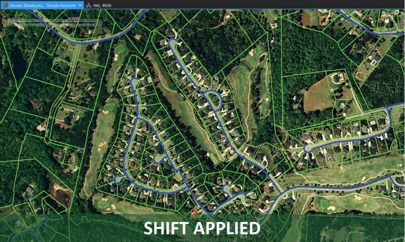
Capture the corridor once; every stage builds on the last — measurable footage becomes detected assets, assets become typed GIS records, and your network is aligned onto the current basemap.
Capture → Feature Extraction → GIS Integration → Conflation
Industries we serve
Built for utilities, cities and transport.
Three industries with the same underlying need — a metric-accurate, always-current digital twin of physical infrastructure. Pick yours below.
Power, water, gas, fibre, tower operators — keeping a GIS that matches field reality, asset by asset.
Customer problems
- Landbase migrations from legacy GIS arrive riddled with positional errors.
- Truck rolls for pole / tower / conductor inspection are expensive and slow.
- Vegetation encroachment forces constant manual ride-throughs to stay compliant.
- your GIS feature classes drift away from on-the-ground reality.
- Smart-grid roll-outs stall on a spatial dataset nobody trusts.
Our solutions
- Drive-by 360° + Lidar capture — one pass replaces dozens of site visits.
- Domain-tuned AI detects poles, transformers, cross-arms, conductors, meters.
- Rigorous constrained least-squares conflation cleans up landbase migrations.
- Detections written 1:1 into your GIS feature classes — no custom importer.
- Repeat drives → automatic delta vs. last capture → ready-to-dispatch work orders.
Business benefits
- 70 – 90 % reduction in field-crew hours per asset class.
- your GIS stays the single system of record — no replatform risk.
- Per-asset condition scoring (rust, sag, clearance) feeds compliance reports.
- Monthly drive cadence replaces annual walk-by surveys.
- Survey-grade geometry stands up to regulator and audit scrutiny.
Municipal authorities and regional governments running streetscape, planning, permitting and resilience together.
Customer problems
- Spatial data is fragmented across departments — roads, parks, utilities, planning.
- Streetscape inventories (signs, lights, hydrants, benches) are years out of date.
- Digital-twin and climate-resilience asks land on a city with no metric-accurate 3D.
- Permits and change-detection workflows lag construction reality by weeks.
- BIM exists only for new builds; the existing stock is opaque.
Our solutions
- City-wide drive-by captures a complete, georeferenced street-level 3D.
- AI detects traffic signals, hydrants, parking meters, signs and vegetation.
- Hosted Digital Twin as a Service — versioned, queryable, streamable.
- Repeat drives produce per-asset-class change reports for every department.
- Building geometry exported as BIM / CIM for retrofit and planning workflows.
Business benefits
- One spatial truth shared across every department and contractor.
- Citizen-facing 3D portals fed from the same dataset planners use.
- Permit cycles compress — impact visualised before approval, not after.
- Insurance and resilience reporting backed by metric, dated evidence.
- Capital plans informed by today's condition, not a five-year-old survey.
Roads, rail, waterways, ports — corridor owners and the HD-map / ADAS programmes that depend on them.
Customer problems
- Road, rail and waterway corridor inventories age out faster than they can be re-walked.
- Bridge undersides and tunnel linings require scaffolding, helicopters or lane closures to inspect.
- Lane markings, signs and guardrails degrade continuously between scheduled audits.
- HD maps for autonomous / ADAS testing go stale within weeks of a re-paving.
- Pavement-condition programmes are slow, patchy and dependent on weather windows.
Our solutions
- Roof-rack rig captures full corridor 360° + Lidar at traffic speed — no closures.
- AI extracts signs, lane markings, guardrails, drainage and clearance at scale.
- UAV-based reconstruction of bridge undersides without scaffolding.
- HD ground truth: lanes, signs, signals with sub-centimetre accuracy.
- Tunnel and cutting clearance measured post-drive, not on-site with a stick.
Business benefits
- Inspection cycles measured in days, not months.
- No lane closures for routine asset capture — survey at traffic speed.
- HD-map vendors and ADAS programmes get fresh ground truth on demand.
- Asset-management systems get survey-grade geometry without GPR or total stations.
- Regulatory compliance (DOT, TfL, Highways agencies) auditable from a single dataset.
Capture
Drive a corridor with the roof-rack 360° camera + GPS rig. The footage is the raw material everything else depends on.
Feature Extraction
Turn the drive into point clouds, photo-real scenes, surface meshes, and asset inventories (poles, wires, vegetation).
GIS Integration
Push detected assets into your enterprise GIS as proper typed records — not just imported geometry.
Phone Video → 3D Point Cloud
A single phone-camera pass around a parked Toyota Land Cruiser, fed into the 4D-360 pipeline. The AI inspects every frame to pick the optimal reconstruction method, then produces a measurable, navigable 3D scene.
Land Cruiser with roof rack and additional equipment parked on a quiet residential street. The vehicle is surrounded by suburban houses, mature trees, and well-maintained lawns. The frames show the camera orbiting around the vehicle, capturing front three-quarter, rear three-quarter, side, and various angled views. The lighting is natural daylight with some overcast conditions, providing even illumination without harsh shadows. The scene has good visual complexity with varied textures from the vehicle's surfaces, foliage, and architectural elements in the background.
Conflation
Copyright © 1984–2026 Walter Hesse, PhD
Rigorous constrained least-squares network adjustment for landbase migrations. Honours straight-line, right-angle, and parallel constraints.
SaaS Performance
Constrained least-squares conflation at scale.
| Parcels | Unknowns | Total time (3 iters) | Per-iter solver |
|---|---|---|---|
| 10 000 | 55 832 | 387 ms | 8–21 ms |
| 40 000 | 241 476 | 1.2 s | 41–57 ms |
| 100 000 | 618 728 | 3.2 s | 123–140 ms |
About 4D-360
Built on four decades of spatial expertise.
4D-360 is built on 45 years of experience in geodesy, photogrammetry, GIS, IT business-system integration, and AI imagery/LiDAR research — delivered for utilities, telcos and smart cities across Australia, New Zealand, the USA, Canada, France, Germany and India. We're actively seeking investors to scale it. Read our story →
Get in touch
Let's build your digital twin as a service (DTaaS).
Utilities, Telcos, Smart Cities, Transport, infrastructure, mining, or mobility — tell us what you need captured and we'll scope the engagement.
Prefer to see it first? Watch the video gallery or read the blog.